Adventures in my scientific career* – past research projects
2017: Eight o'clock is rockfall time - Pattern and trigger screening in the Lauterbrunnen Valley
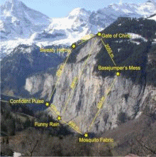
Rockfall is a widespread mass wasting process, yet hard to constrain by classic methods. Seismic approaches may provide access to detecting, locating and analysing of rockfalls and likewise allow investigation of possible triggers by delivering high precision time control of the events. In the Lauterbrunnen Valley, Switzerland, activity was monitored seismically for six months. The results were cross-checked with terrestrial laser scanning (performed by Solmaz Mohadjer, University of Tübingen). The project successfully aimed at i) investigating the overall ability of seismically detecting and locating rockfalls, the minimum detectable size of a rockmass, and the location precision; ii) linking rockfall activity to environmental triggers such as precipitation, thermal forcing and earthquakes; and iii) detecting patterns in space and time at different scale levels. Apparently, rockfalls as small as 0.05 cubic metres can be detected with an overall deviation of about 80 m. Rockfalls are mainly driven by precipitation (only a few by freeze-thaw action) and diurnal thermal forcing. The overall diurnal pattern yields acitivty maxima around eight o'clock.
Find here a video that visualises and sonifies an hour of environmental activity in the Lauterbrunnen Valley as sensed by a broadband seismometer. A small earthquake, sounding like a cannon shot, is followed by a rockfall that sounds like a gun shot. Later on there is the whale sound-like signature of a train going back and forth along the top of the limestone cliff.
FURTHER READING: Dietze et al. (2017a, 2017b)
2016: Closing the loop – Telling stories from dust under stone pavements.
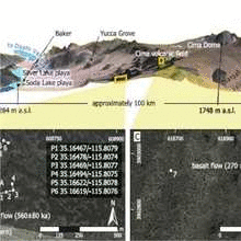
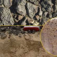
Stone pavements are widespread surface features in deserts globally. They are the result of the deposition of dust (yes indeed, deposition, not erosion) and can thus form continuously thickening recorders of the environmental conditions during which they formed. A showcase scenario of this idea can be found in the eastern Mojave Desert, California, USA, where deposts on basalt flows of different age show a consistent stratigraphic relationship. Three subsequent units, which are dominated by aeolian material, are covered by a stone pavement (the last one being the modern surface). They were deposited >50.9–36.6 ka, 36.6–14.2 ka and younger than 14.2 ka, and they are intimately coupled with the history of nearby Lake Mojave. Stone pavement-covered accretionary deposits are a new key archive that allows quantifying the relative importance of dust accretion, slope processes, soil formation and vegetation cover.
There are a couple of side stories to tell about this project as it was a long winding road to get it finished. Most imporantly, it wraps up several of the earlier research projects and closes a loop of work that started almost 10 years earlier.
FURTHER READING: Dietze et al. (2016)
2015: More sediment tools – The R-package grainsize.
After finishing the work on the R-package EMMAgeo and enganging with the Geomorphology Section in Potsdam, ways were open for plenty of high resolution grain-size data, ready to be used. Given, a proper software is there to handle data from different devices and approaches in a coherent way. Sadly, every manufacturer creates its own suite of tools to handle their data. This led to the development of a further R-package to account for this drawback. The package grainsize is currently used in the sediment laboratory of the Geomorphology Section and focused on import and processing of laser diffraction devices (Beckman Coulter, Retsch) and optical imaging devices (Retsch). If anyone is interested in support of further devices, please let me know and I will see what is possible. It is also planned to write functions beyond import and preparation of data, to be able to also run classic analysis steps (e.g., Folk and Ward's method of moments parameters), link to the R-package EMMAgeo and provide high-quality plot functions.
2014: Working with signals from the Earth surface – the R-package eseis.
Environmental seismology is an emerging research field that investigates the seismic signals emitted by Earth surface processes. It welds geomorphology and seismology. A basic need for me to engage with this rich sector of the Earth surface playground was to adopt and develop the numeric tools to handle the vast amount of data. Although there are plenty of specified software tools already available, it was hardly possible to merge seismic signal processing with analysis tools and concepts of geomorphic fields, such as spatial data and meteorologic time series. However, these intimate links between adjacent (and not so adjacent) scientific fields is the key goal of environmental seismology. Hence, it became necessary to write an R-package (eseis) that allows import/export of seismic data, the most commonly used data preparation tools and specialised approaches to localise and estimate the enrgetic characteristics of seismic sources due to Earth surface processes.
FURTHER READING: Turowski et al. (2016),
R-package eseis
2014: Introducing the R-package EMMAgeo for unmixing grain-size distributions.
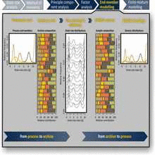
The grain-size distributions of sediments carry vital information about the source area, the sediment is derived from, the transport pathways it is routed along, the transport and depositional processes it is subject to as well as the postdepositional fate it has experienced. However, due to the multitude of processes affecting a set of grains during their life cycle the grain-size distributions are usually polymodal mixtures of many different subpopulations. Disentangling and quantifying the useful parts of this mess requires both, high-resolution measurements and a technique to statistically unmix these subpopulations. While the former is no longer an issue since the advent of laser diffraction or direct image processing devices, the latter was still challenging. End-member modelling analysis (EMMA) is one promising approach to quantitatively unmix grain-size distributions. Based on a Matlab-script of my dear wife, I wrote a package (EMMAgeo) for handling the complete workflow of EMMA in R, also in a robust form, i.e. accounting for the uncertaintines associated with unknown parameter estimates. The package is on CRAN and has been widely used, not only for grain-size data sets but also for unmixing hydrologic data, pollen samples and also seismic data.
FURTHER READING: Dietze et al. (2016),
R-package EMMAgeo
2013: Disentangling desert dust depostions in Jordan deserts.
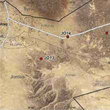
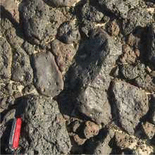
Deserts are marvellous, and they are not only full of sand. In fact, they are mostly covered by gravel, forming a stone pavement. And below the gravel, there is not even more gravel but in many cases a layer of fine, aeolian dust. Based on previous studies in North- and South American Deserts it appeared interesting to study the nature of such aeolian deposits below stone pavements in the Jordan Desert. The extreme topography-controlled climate and long-term stability of the terrain make this desert an ideal case. Like in the Mojave Desert, the aeolian deposits in Jordan are much younger than the overlying basal gravels, implying the successive incorporation of freshly deposited aeolian material into a thickening mantle below the surficial gravel layer. Distinct and systematic age differences between the sandy and silty fraction of the deposited material (like in other studies) point at a non-uniform incorporation mechanism.
FURTHER READING: Fuchs et al. (2015)
2012: Shifting luminescence dating from spreadsheets to real software – contribution to the R-package Luminescence.
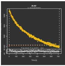
Luminescence dating is the only technique that delivers the depositional age of sediments and has become the standard for delivering direct ages in depositional environments. The way from taking a sample to presenting the final age is rocky and winding, with many bifurcations. You learn this especially when you try to start building a lab from scratch. One of the deepest and obscure parts of this methodological jungle covers the way from raw measurement files to the final age estimates. Each lab used to have and many still have their own software cookbooks and receipies to navigate through this jungle. Thanks to Sebastian Kreutzer, who was enthusiastic enough exactly at the right time of his PhD project to start from scratch writing most of the essential functions and tools to transform measurement files to ages in a free and open software (R), we can now benefit from the R-package Luminescence. Worldwide this package has been downloaded more than 5000 times and many labs use it as standard, now. I was delighted to contribute my part to enriching the package, mostly in terms of visualising data. Among these plot functions is the Abanico Plot, a plot decisively dedicated to comprehensively showing age data with individual errors. I am part of the developer team since 2011 and this project has become one of the most proactive engagements in a marvelous team.
FURTHER READING: Fuchs et al. (2014),
Dietze et al. (2013),
Kreutzer et al. (2012),
R-package Luminescence
2012: A million years in a second – integrating CHILD to R with the package RCHILD.
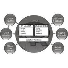
After the PhD project was finished, I decided to shift more than one focus of my work: scales, questions, techniques, research areas. A goal was not to shift to another fixed scale, question and study area but to look for a flexible tool that could be adopted to as many of these points as possible. One obvious target that could cover all these demands was landscape evolution modelling, especially on temporal scales below 50000 years and spatial scales below 500 square km (though not necessarily restricted to these). The model CHILD appeared to be the most flexible one at that time, but when fiddeling around with the code (not speaking of compilation) and especially the output of the model it became clear that an interface to another software was necessary ot handle the output and perform further analyses. R was one of these other software options. Even more, while writing the package, it emerged that rather than just reading the output, one could also implement writing the input files for CHILD by R and even running the model through R. Thus, CHILD became the working horse and R the main manipulation and research tool. The package borrows heavily from Greg Tuckers Matlab scripts but included further links to spatial and temporal analysis functions.
FURTHER READING: R-package RCHILD
2012: How to move stones through the desert – new processes of stone pavement formation.
Before answering the "how-question", here is the answer to the "why-question": Because we need to find a way to laterally move stones onto and over a mantle of fine-grained, mainly aeolian material, very common in deserts. And we need to find this way because otherwise we could not explain several generations of stone pavements buried on top of each other in these mantles. The tricky part is to move cm to dm large clasts but at the same time not to erode the sandy to silty material that forms the mantle. And, finally, we need to explain how in many areas, the length axes of stone pavement clasts show a bimodal orientation pattern, with clasts deviating from slope aspect by 40 ° to both sides. From field experiments, laboratory experiments and numeric modelling exercises two distinct, yet unknown processes emerged: moving clasts by unconcentrated overland flow and moving clasts by air that escapes from the sediment and thereby repeatedly lifts clasts and lets them settle down.
FURTHER READING: Dietze et al. (2013),
Dietze & Kleber (2012)
2011: How to create bubbles in dust – formation of vesicular horizons in deserts.
Despite its funny impression at a first glance, "bubbles in dust" have received a scientific name: "vesicles" or "vesicular horizon" (Av) – for good reasons. It is the vesicular horizon that reduces infiltration capacity of desert soils by two orders of magnitude, that stabilises the loose fine material and prevents deflation, that keeps the coupled system of accretionary soil development of stone pavement covered areas going and that determines ecological characteristics in deserts in an outstanding way. No surprise that the formation of such a horizon with its sponge-like appearance yielded so many contradicting hypotheses on how it actually forms. In a set of comprehensive experiments and field studies along a climatological gradient in North America all these hypotheses were tested and rejected, except for one: a downward migrating wetting front replaces air and increases the gas pressure within the sediment, which inflates existing pores to shperical vesicles. Beyond these tests, the main environmental and sedimentological boundary conditions for vesicle formation were quantified.
FURTHER READING: Dietze et al. (2012)
2010: Landscape evolution at 5000 m asl. – Nevado Tres Cruces, Atacama Desert.
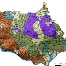
The Valle de Barrancas Blancas is a remote closed basin in the Atacama Desert at elevations above 5000 m asl. It contains a series of well preserved landforms resulting from a unique combination of slope, aeolian, lacustrine/ litoral, fluvial, glacial and periglacial regimes. They permit insight into the full range of geomorphological processes within this isolated catchment. The landscape comprises modern subsurface features, which were not documented before and are presumably crucial for e.g. water management within the area and beyond. Basal ice outcrops below more than 400 ka old, 200 m thick volcanoclastic deposits may represent significantly older than modern ice complexes. Prominent shore line features with distinct and systematic pedological properties suggest a palaeolake succession with up to 12 stages. Stone pavement-covered, loess-like deposits indicate several periods of aeolian activity. Presumably the entire catchment exhibits permanently frozen ground at less than 50 cm depth, covered by mostly dry, partially water-saturated sediment. This finding may lead to a better understanding of water sources, flow paths and, hence, water management strategies in High Atacama regions outside the Valle de Barrancas Blancas catchment.
2007: Modelling cover bed thickness and material properties.
Soils of Central European subdued mountain ranges are structured by various layers of relic periglacial slope deposits. These have great impact on subsurface substrate properties. Therefore, coherent spatial information on material composition and thickness of slope deposits is essential. Based on more than 50 auger probes and a conceptual process-focused model, a GIS-based numeric approach has been developed and validated. The three distinct sedimentological units are created by cryoturbation, solifluction and admixture of aeolian material. These three processes have been parameterised. Layer thickness was modelled by cokriging using supporting topography factors, layer distribution was modelled using a modified multiple flow direction algorithm. Modelling returned thicknesses of loess-bearing layers, i.e. upper layer and intermediate layer. The model error of the upper layer was < 10 cm for 75% of the validation data (< 15 cm for 90%), i.e. RMSE of 10 cm and standard deviation of 10 cm). Intermediate layer thickness was approximated with an error of < 5 cm for 75% of the validation data (< 6 cm for 90%). The modified flow model is able to predict the distribution of rock types dislocated from their original outcrops very accurately, except for basalt clasts, which were transported farther than predicted.
FURTHER READING: Kleber & Terhorst (2013),
Dietze et al. (2010),
Dietze et al. (2008),
2006: Discovering Volkonskoite, a rare chromium-bearing smectite.
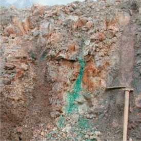
Intensive green fissure fillings were found during new quarry activities in Potschappel, near Dresden, Germany. These fillings consist of bentonitisised porphyrite. Among the mixture of beidellitic smectite and nontronite there is a peculiar chromium-bearing smectite, called Volkonskoite. This rare clay mineral species was first described 1831 from the Ochanskyii Oblast of the Permian governement. It was so far not discovered in Germany and is defined as a dioctahedral mineral of the smectite group containing chromium as the dominant trivalent cation in the octahedral sheet.
FURTHER READING: Dietze et al. (2007)
* Quoting Wikipedia, "A career is an individual's journey through learning, work and other aspects of life". So adventures appears to be a quite good match.